For not too extended sources (compared to the point spread function) the maximum likelihood technique can be applied to determine the source extent.
A user defined table with the source coordinates right ascension and declination (in degrees and for equinox 2000.0) and with the column labels :RA_DEG and :DEC_DEG has to be provided. Such a table can be created with the EXSAS command
Midas 001> write/radec_table mysource RA=85.0940 DEC=-69.3340in case the coordinate input is in decimal degrees for right ascension and declination or
Midas 001> write/radec_table mysource RA=5,40,22.6 DEC=-69,20,2.4in case the coordinate input is in hours,minutes,seconds for right ascension and degrees,minutes,seconds for declination. Now a maximum likelihood fitting is performed with the commands
Midas 002> create/parfil EXSP extent ROSAT,PSPC
Midas 003> detect/maxlik extent edit
The parameter file extent.par is created and offered to be edited. The parameters in the file extent.par must be assigned the proper values. The cut-radius has been set to a large number of 20 times the FWHM to be sure to encircle the whole source. The position is allowed to vary in the fit (parameter FIT_POSITION is set to free). A (smoothed) background image has to be provided. In the previous chapter it is described how to create such an image. Only those parameters of the parameter file extent.par which have to be modified are given below:
!
! parameter file for DETECT/MAXLIK - task  EXSP
!
INPUT_DATASET        testdata1:events.tbl  ! name of events table
AMPLITUDE_LOW        11                    ! lower amplitude bound
AMPLITUDE_HIGH       235                   ! upper amplitude bound
CUT_RADIUS           20.0                  ! cut radius in FWHM
ML_THR               0.00                  ! threshold of -ln(p)
START_POSITION       user_list             ! detection mode
FIT_POSITION         free                  ! fit source position
USER_LIST            mysource.tbl          ! user source list
A source table solst.tbl with the columns :EXT
and :EXTERR is created specifying the source extent as
one Gaussian ![]() and its error in image pixels.
The source intrinsic width
can be compared with the spread of the source due to
the point spread function of the instrument. The FWHM of the
point spread function (evaluated for the calibrated amplitude 50)
can be calculated with the two commands
and its error in image pixels.
The source intrinsic width
can be compared with the spread of the source due to
the point spread function of the instrument. The FWHM of the
point spread function (evaluated for the calibrated amplitude 50)
can be calculated with the two commands
Midas 004> transform/coord solst solst_2000
Midas 005> calculate/psf G P 50,{solst_2000,:OFFAX},{solst_2000,:FWHM,@1}
The first command creates a coordinate table (giving also the x,y sky pixel position), the second command calculates the FWHM from the source sky pixel position taking into account the mean pointing direction of the telescope axis (determined from the mean attitude offset). The value of the FWHM (in arc seconds) is written to the keyword OUTPUTD(5). The coordinates of the source have been slightly modified in the course of the likelihood fit. We read the new equatorial coordinates :RA_DEG and :DEC_DEG
Midas 006> read/tab solst_2000 :RA_DEG :DEC_DEG

  Table : solst_2000

 Sequence RA_DEG    DEC_DEG
 -------- --------- ---------
        1  85.03923 -69.33409
 -------- --------- ---------
We read the value of the extent of the source :EXT, the extent
error :EXTERR (in image pixels) and the extent likelihood
:EXT_ML from the table solst.tbl
Midas 007> read/tab solst :EXT :EXTERR :EXT_ML

  Table : solst

 Sequence EXT    EXTERR EXT_ML
 -------- ------ ------ ------
        1   2.82  2.093    2.3
 -------- ------ ------ ------
and we read the value of the FWHM of the source (in arcsec)
from the keyword OUTPUTD(5)
Midas 008> read/key OUTPUTD

keyword: OUTPUTD   type: double   no. of elements: 20   modtime: 769113421
       37.789909362792969       354.81793212890625       354.81793212890625
                       50          163.80712890625       37.789909362792969
      0.96127396821975700       37.789909362792969       354.81793212890625
                        0                        0                        0
                        0                        0                        0
                        0                        0                        0
                        0                        0
To compare EXT and EXTERR with FWHM
conversion from image to sky pixels has to be done with
the descriptor STEP from any of the two tables.
In this example STEP(1) = 30 sky pixels.
This means the source extent is 2.82 The position of the source in sky pixel coordinates can be read from the table solst_2000.tbl.
Midas 009> read/tab solst_2000 :X_SKY :Y_SKY

  Table : solst_2000

 Sequence X_SKY            Y_SKY
 -------- ---------------- ----------------
        1           536.00         -4503.00
 -------- ---------------- ----------------
Another tool to get the source extent is to calculate the ring
integrated profile (radial profile) of a source. To apply it to
the photon event table testdata1:events.tbl (in the
testdata area testdata1) and for a source at x-position 536.
sky pixels and y-position -4503. sky pixels in a circle with a
radius of 750. sky pixels the command is
Midas 010> plot/ring testdata1:events 536.,-4503.,750.The result is shown in Figure 5.9.
To calculate the radial profile of a source from the image data another command is available. First read the image coordinates of the source
Midas 011> read/tab solst :X_IMA :Y_IMA

  Table : solst_2000

 Sequence X_IMA       Y_IMA
 -------- ----------- -----------
        1      274.38      106.42
 -------- ----------- -----------
Now apply the command
Midas 012> draw/radial_profile testdata1:image 274.38,406.58,25. ? ? grapThe result is shown in Figure 5.10. Attention, the y image pixel coordinate, Y_IMA, in the source table is flipped with respect to the coordinate system of the Midas display (see section 5.2.24). calculated as 512 + 1 - 106.42 = 406.58
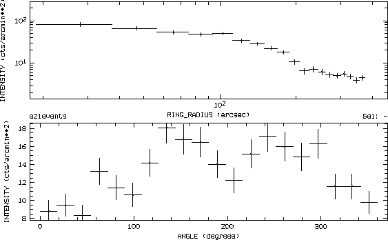
Figure 5.9:
Radial (upper figure) and azimuthal (lower figure) intensity
profile drawn with the command PLOT/RING_PROFILE
from photon event file data.
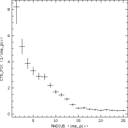
Figure 5.10:
Radial intensity profile drawn with the command
DRAW/RADIAL_PROFILE from image data.