

Next: Create a User defined
Up: 5.2 Tasks of the
Previous: Calculate Counts within a
Source positions may be given in image pixels, sky pixels, detector
pixels, equatorial coordinates right ascension (degrees) and
declination (degrees), ecliptic longitude (degrees) and latitude
(degrees) and galactic longitude (degrees) and latitude (degrees).
Sky pixels are specified relative to a pointing direction.
This pointing direction in case of EXSAS is specified by the
descriptors POINT_LONG and POINT_LAT.
The sky coordinates of the pointing direction are given in the
descriptors SKY_CEN_X and SKY_CEN_Y,
cf. Table
5.32.
Detector coordinates are specified with respect to the optical axis
of the instrument. The detector center is given in the descriptors
DET_CEN_X and DET_CEN_Y. The length of a sky
pixel in arc seconds is expressed by the descriptor
SKY_PIX_SIZE and the length of a detector pixel by the
descriptor DET_PIX_SIZE.
In source tables provided by the source detection
the coordinates of the source positions are
expressed in sky pixels and/or in image pixels. They can be
converted to sky pixels, equatorial, ecliptic and galactic
coordinates with the command
TRANSFORM/COORDINATES in_table [out_table] [equinox] -
                      [ref_image] [dist_flag] [ampl]
- in_table is the name of the source table with the
columns :INDEX, :X_SKY and :Y_SKY
( or :X_IMA and :Y_IMA ( or
:X_POS and :Y_POS ) ) and
with the EXSAS header descriptors. In case the sky pixel columns
are existing, they are used for the coordinate transformation,
if not the image pixel columns :X_IMA and :Y_IMA
are used and if they are not existing the image pixel coordinates
:X_POS and :Y_POS are accessed.
- out_table is the name of the coordinate table with
columns :INDEX, :X_POS, :Y_POS,
:X_SKY, :Y_SKY, :RA_DEG,
:DEC_DEG, :RA_HMS and :DEC_DMS and
with the EXSAS descriptors. The default is trans.tbl
- equinox is the equinox (in decimal centuries) for which the
right ascension and the declination will be calculated.
The default value is 2000.0.
- ref_image is the name of the reference image from
which Midas standard and EXSAS general descriptors are read.
If no reference image is given the descriptors are
read from in_table, which is the default case.
- dist_flag is a flag specifying whether the distance to
the next neighbour (source), the off-axis angle and the FWHM
of the source shall be calculated (y) or
not (n). In case of big tables the distance calculation
slows down the calculation enormously. Then the setting
dist_flag=n is recommended.
- ampl is the calibrated amplitude for which the FWHM is
calculated. The default is ampl = 7.
Examples are:
TRANSFORM/COORDINATES solst coo\_solst
TRANSFORM/COORDINATES solst coo\_solst 1950.0
TRANSFORM/COORDINATES mytable mycoord 2000.0 image1
TRANSFORM/COORDINATES long\_table long\_coord 2000.0 image n
In the third example the name of the source table is
mytable.tbl, the name of the transformed table is
mycoord.tbl, the equinox for the coordinates is 2000.0.
A reference image image1.bdf has been specified
which contains the general EXSAS descriptors.
A reference image has to be given in case the source table does
not contain a set of general EXSAS descriptors and of general MIDAS
descriptors. In the standard source detection case
a reference image has not to be specified.
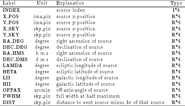
The transformed table contains the information listed in
Table 5.23.

Table 5.23: Coordinate information created by TRANSFORM/COORDINATES
A description of the information provided by the coordinate tables
is given below.
- INDEX is the source index number.
- X_POS is the source x-position in units of image pixels.
Image pixels are always given with respect to a reference image.
- Y_POS is the source y-position in units of image pixels.
This coordinate is flipped as NPIX(2) + 1 -y.
Image pixels are always given with respect to a reference image.
- X_SKY is the source x-position in units of sky pixels.
Sky pixels are specified relative to a pointing direction given in
the descriptors POINT_LAT and POINT_LONG.
The x,y sky pixels coordinates of the pointing direction are given
in the descriptors SKY_CEN_X and SKY_CEN_Y,
respectively.
- Y_SKY is the source y-position in units of sky pixels.
Sky pixels are specified relative to a pointing direction given in
the descriptors POINT_LAT and POINT_LONG.
The x,y sky pixels coordinates of the pointing direction are given
in the descriptors SKY_CEN_X and SKY_CEN_Y,
respectively.
- RA_DEG is the right ascension in decimal degrees for equinox
specified in the descriptor EPOCH.
- DEC_DEG is the declination in decimal degrees for equinox
specified in the descriptor EPOCH.
- RA_HMS is the right ascension in hours,minutes,seconds
for equinox specified in the descriptor EPOCH.
The representation is as 05H42M10.0S
in case of 5 hours, 42 minutes and 10.0 seconds.
- DEC_DMS is the declination in degrees,minutes,seconds
for equinox specified in the descriptor EPOCH.
The representation is as -69D30M25.0S
in case of -69 degrees, 30 minutes and 25.0 seconds.
- LAMDA is the ecliptic longitude in decimal degrees for equinox
specified in the descriptor EPOCH.
- BETA is the ecliptic latitude in decimal degrees for equinox
specified in the descriptor EPOCH.
- LII is the galactic longitude in decimal degrees.
- BII is the galactic latitude in decimal degrees.
- OFFAX is the off-axis angle (with respect to the position
specified in the SKY_CEN_X and SKY_CEN_Y
descriptors). This value is different from the true
off-axis-angle in case the sky position SKY_CEN_X,
SKY_CEN_Y is not mapped to the detector center.
- FWHM is the FWHM of the point spread function in units of sky
pixels in the Gaussian model. The FWHM is evaluated at the
calibrated amplitude channel AMPL=7. The off-axis-angle is
calculated with respect to the SKY_CEN_X,
SKY_CEN_Y position.
- DIST is the distance of the source to the nearest neighbour
source in the coordinate table minus (
 the
Gaussian
  ) of that source in units of
sky pixels.
Equatorial coordinates can be converted to image pixel and sky pixel
coordinates with the command
TRANSFORM/RADEC_TO_PIXEL in_table [out_table] [ref_image] [equinox]
- in_table is the name of the coordinate table with
columns :RA_DEG for right ascension (degree) and
:DEC_DEG for declination (degree).
- out_table is the name of the transformed coordinate
table with the columns :INDEX, :RA_DEG,
:DEC_DEG, :X_IMA, :Y_IMA, :X_SKY
and :Y_SKY and with the general EXSAS descriptors from
ref_image.
- ref_image is the name of the reference image with
the EXSAS header descriptors.
- equinox is the equinox for which right ascension and
declination are specified. The default value is 2000.0.
Example:
TRANSFORM/RADEC_TO_PIXEL equ_coord pix_coord myimage 2000.0
In this example the name of the coordinate table is
equ_coord.tbl and the equatorial coordinates are specified
for equinox 2000.0, the name of the transformed coordinate table is
pix_coord.tbl and the name of the reference image is
myimage.bdf. A reference image has to be specified in any case.
The equatorial longitude and latitude of the source must be specified
in decimal degrees and has to be written to the standard columns
:RA_DEG and :DEC_DEG.
Equatorial coordinates can be converted to ecliptic and galactic
coordinates (and vice versa) with the command
TRANSFORM/EQU_ECL_GAL in_table [out_table] [equinox] [ref_sys]
- in_table is the name of the coordinate table with
the columns :RA_DEG for right ascension (degrees)
and :DEC_DEG for declination (degrees).
- out_table is the name of the transformed coordinate
table with the columns :INDEX, :RA_DEG,
:DEC_DEG, :LAMDA, :BETA, :LII
and :BII.
- equinox is the equinox for which the right ascension
and the declination are specified. The default is 2000.0.
- ref_sys is the coordinate reference system.
Coordinates must be specified in this system.
EQU = equatorial (columns :RA_DEG and :DEC_DEG are evaluated),
GAL = galactic (columns :LII and :BII are evaluated),
ECL = ecliptic (columns :LAMDA and :BETA are evaluated).
Example:
TRANSFORM/EQU_ECL_GAL equ_coord ecl_gal_coord
TRANSFORM/EQU_ECL_GAL equ_coord ecl_gal_coord ? GAL
Note:The coordinates have to be specified for equinox 2000.0. With the
Midas command COMPUTE/PRECESS equatorial coordinates can be
precessed from any equinox to equinox 2000.
Equatorial, ecliptic and galactic coordinates have to be specified in
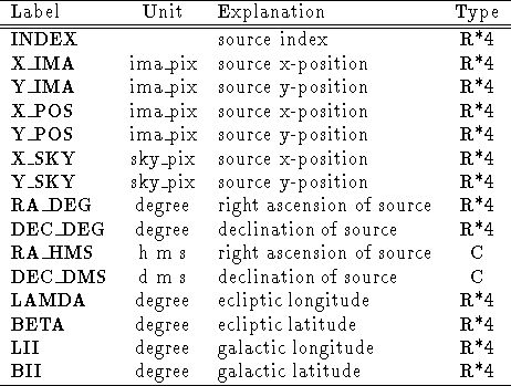
degrees. The standard column labels are listed in
Table 5.24.

Table 5.24: Standard labels for the TRANSFORM commands
The format is not fixed if a user provides his own table. As the
commands to transform coordinates works on Midas tables with default
names for the column labels, the user has to provide a MIDAS table
with those columns. This he can do with the command
WRITE/RADEC_TABLE (see section
5.2.30
in case of ref_sys = EQU.


Next: Create a User defined
Up: 5.2 Tasks of the
Previous: Calculate Counts within a
If you have problems/suggestions please send mail to
rosat_svc@mpe-garching.mpg.de


