From NASA's Planetary Photojournal
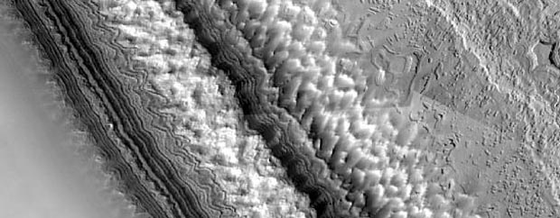
The layered terrains of the polar regions of Mars are among the most exotic planetary landscapes in our Solar System. The layers exposed in the south polar residual cap are thought to contain detailed records of Mars' climate history over the last 100 million years or so. The materials that comprise the south polar layers may include frozen carbon dioxide, water ice, and fine dust. Because the south polar terrains are so strange and new to human eyes, no one (yet) has entirely adequate explanations as to what is being seen.
This images were acquired by the Mars Orbiter Camera aboard the Mars Global Surveyor spacecraft during the southern spring season in October 1999. It a mosaic of many individual MOC images acquired at about 12 m/pixel scale that completely cover the highest latitude (87 degree S) visible to MOC on each orbital pass over the polar region. It covers an area of about 10 x 4 kilometers (6.2 x 2.5 miles) near 87 degree S, 10 degrees W in the central region of the permanent--or residual--south polar cap. It shows features at the scale of a small house. Sunlight illuminates from the left.
Image Title: High-Resolution South Polar Cap Mosaic
Catalog #: PIA02390
Target Name: Mars
Spacecraft: Mars Global Surveyor Orbiter
Back to Mars photographs index.
© Copyright 2000 Outreach Consortium. All Rights Reserved.Last Modified On: Monday, December 18, 2000