From NASA's Planetary Photojournal
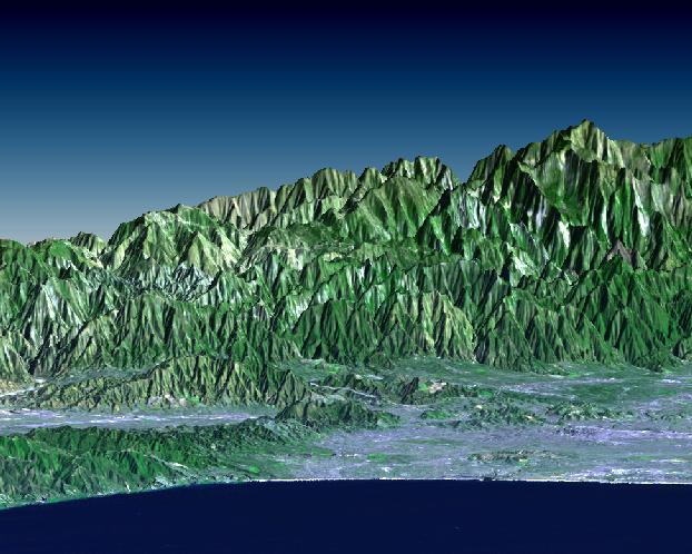
Los Angeles, the world's entertainment capital, is a difficult place to locate television and radio antennas. The metropolitan area spreads from the Pacific Ocean to Southern California's upper and lower deserts, valleys, mountains, canyons and coastal plains. While this unique geography offers something for everyone in terms of urban, suburban, small-town, and even semi-rural living, reception of television and radio signals can be problematic where there is no line-of-sight to a transmitting antenna. Broadcasters must choose antenna sites carefully to reach the greatest number of customers. Most local television towers are located atop Mount Wilson (elevation 1740 m = 5710 ft), which is located on the front range of the San Gabriel Mountains (indistinctly visible, just right of the image center). This site is preferable to the highest peak seen here (Mount Baden-Powell, 2865 m = 9399 ft) because it's closer to the urban center and has fewer obstructing peaks. It is also situated at a protruding bend in the mountain front and has few obstructions to the left and right.
This perspective view looks northeastward from the Santa Monica Bay. The San Fernando Valley is on the left, Pasadena is against the mountain front at right-center, and downtown Los Angeles is on the coastal plain directly in front of Mount Baden-Powell. This image was generated by draping a Landsat satellite image over a preliminary topographic map from the Shuttle Radar Topography Mission (SRTM). Landsat has been providing visible and infrared views of the Earth since 1972. SRTM elevation data matches the 30-meter resolution of most Landsat images and will substantially help in analyses of the large and growing Landsat image archive.
The elevation data used in this image was acquired by the Shuttle Radar Topography Mission aboard the Space Shuttle Endeavour, launched on February 11, 2000. SRTM used the same radar instrument that comprised the Spaceborne Imaging Radar-C/X-Band Synthetic Aperture Radar (SIR-C/X-SAR) that flew twice on the Space Shuttle Endeavour in 1994. SRTM was designed to collect three-dimensional measurements of the Earth's surface. To collect the 3-D data, engineers added a 60-meter-long (200-foot) mast, installed additional C-band and X-band antennas, and improved tracking and navigation devices.
Image Title: SRTM Perspective View with Landsat Overlay: Santa Monica Bay to Mount Baden-Powell, California
Catalog #: PIA02779
Target Name: Earth
Spacecraft: Shuttle
Back to Earth photographs index.
Last Modified On: Tuesday, December 19, 2000