From NASA's Planetary Photojournal
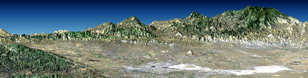
Antelope Valley is bounded by two of the most active faults in California: the Garlock fault, which fronts the distant mountains in this view, and the San Andreas fault, part of which is seen bounding the mountains in the left foreground. In this view, Antelope Valley is in the foreground, the Tehachapi Mountains form the left skyline, and ranges within the southernmost Sierra Nevada form the right skyline. Antelope Valley is directly north of Los Angeles and is the westernmost part of the Mojave Desert. It is a closed basin. Stream flow here ends at Rosamond and Edwards dry lakes, which appear bright white. Dry lakes like these are common where tectonic activity raises and lowers parts of the Earth's crust, and thus the topographic surface, faster than stream flow can fill depressions with water, and then overflow and cut escape channels to other basins and eventually to the sea. The Sierra Nevada, the Tehachapi, and other mountains generally to the west create a rain shadow desert here. Thus, the area definitely has the active tectonics and low rainfall combination that leads to closed basin topography.
This perspective view was generated by draping a Landsat satellite image over a preliminary topographic map from the Shuttle Radar Topography Mission. Shading of the SRTM elevation model was added to enhance topographic appearance. SRTM elevation data matches the 30 meter resolution of most Landsat images and will substantially help in analyses of the large and growing Landsat image archive.
The elevation data used in this image was acquired by the Shuttle Radar Topography Mission (SRTM) aboard the Space Shuttle Endeavour, launched on February 11, 2000. SRTM used the same radar instrument that comprised the Spaceborne Imaging Radar-C/X-Band Synthetic Aperture Radar. SRTM was designed to collect three-dimensional measurements of the Earth's surface. To collect the 3-D data, engineers added a 60-meter-long (200-foot) mast, installed additional C-band and X-band antennas, and improved tracking and navigation devices.
Image Title: Perspective with Landsat Overlay: Antelope Valley, California
Catalog #: PIA02775
Target Name: Earth
Spacecraft/Mission: Shuttle Radar Topography Mission
Back to Earth photographs index.
Last Modified On: Tuesday, December 19, 2000