From NASA's Planetary Photojournal
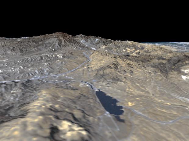
The prominent linear feature straight down the center of this perspective view is the San Andreas Fault in an image created with data from NASA's Shuttle Radar Topography Mission (SRTM). This segment of the fault lies west of the city of Palmdale, California, about 100 kilometers (about 60 miles) northwest of Los Angeles. The fault is the active tectonic boundary between the North American plate on the right, and the Pacific plate on the left. Relative to each other, the Pacific plate is moving away from the viewer and the North American plate is moving toward the viewer along a right lateral strike-slip fault. This area is at the junction of two large mountain ranges, the San Gabriel Mountains on the left and the Tehachapi Mountains on the right. Quail Lake Reservoir sits in the topographic depression created by past movement along the fault. Interstate 5 is the prominent linear feature starting at the left edge of the image and continuing into the fault zone, passing eventually over Tejon Pass into the Central Valley, visible at the upper left.
This type of display adds the important dimension of elevation to the study of land use and environmental processes as observed in satellite images. The perspective view was created by draping a Landsat satellite image over an SRTM elevation model. Topography is exaggerated 1.5 times vertically. The Landsat image was provided by the United States Geological Survey's Earth Resources Observations Systems (EROS) Data Center, Sioux Falls, South Dakota. Elevation data used in this image was acquired by the Shuttle Radar Topography Mission (SRTM) aboard the Space Shuttle Endeavour, launched on February 11, 2000. SRTM used the same radar instrument that comprised the Spaceborne Imaging Radar-C/X-Band Synthetic Aperture Radar (SIR-C/X-SAR) that flew twice on the Space Shuttle Endeavour in 1994.
Image Title: Perspective View, San Andreas Fault
Catalog #: PIA02746
Target Name: Earth
Spacecraft: Shuttle
Back to Earth photographs index.
Last Modified On: Tuesday, December 19, 2000