From NASA's Planetary Photojournal
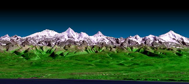
This perspective view shows the western side of the volcanically active Kamchatka Peninsula in eastern Russia. It was generated using the first data collected during the Shuttle Radar Topography Mission (SRTM). In the foreground is the Sea of Okhotsk. Inland from the coast, vegetated flood plains and low relief hills rise toward snow capped peaks. The topographic effects on snow and vegetation distribution are very clear in this near-horizontal view. Forming the skyline is the Sredinnyy Khrebet, the volcanic mountain range that makes up the spine of the peninsula. High resolution SRTM topographic data will be used by geologists to study how volcanoes form and to understand the hazards posed by future eruptions.
This image was generated using topographic data from SRTM and an enhanced true-color image from the Landsat 7 satellite. This image contains about 2,400 meters (7,880 feet) of total relief. The topographic expression was enhanced by adding artificial shading as calculated from the SRTM elevation model. The Landsat data was provided by the United States Geological Survey's Earth Resources Observations Systems (EROS) Data Center, Sioux Falls, South Dakota.
SRTM, launched on February 11, 2000, used the same radar instrument that comprised the Spaceborne Imaging Radar-C/X-Band Synthetic Aperture Radar (SIR-C/X-SAR) that flew twice on the Space Shuttle Endeavour in 1994. To collect the 3-D SRTM data, engineers added a 60-meter-long (200-foot) mast, installed additional C-band and X-band antennas, and improved tracking and navigation devices.
Image Title: 3-D Perspective View, Kamchatka Peninsula, Russia
Catalog #: PIA02740
Target Name: Earth
Spacecraft: Shuttle
Back to Earth photographs index.
Last Modified On: Tuesday, December 19, 2000