From NASA's Planetary Photojournal
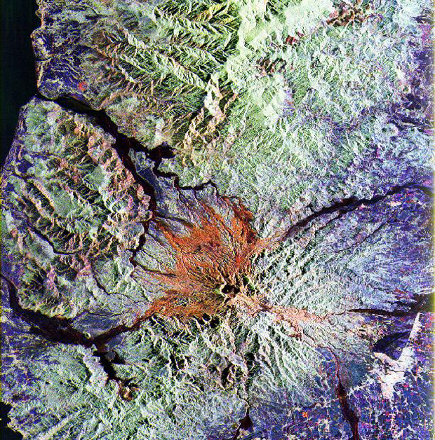
This is a false color L-band and C-band image of the area around Mount Pinatubo in the Philippines, centered at about 15 degrees north latitude, 120.5 degrees east longitude. This image was acquired by the Spaceborne Imaging Radar-C and X-Band Synthetic Aperture Radar (SIR-C/X-SAR) aboard the space shuttle Endeavour on orbit 78 on April 13, 1994. The false-color composite is made by displaying the L-band HH return in red, the L-band HV return in green and the C-band HV return in blue. The area shown is approximately 45 by 68 kilometers (28 by 42 miles). The main volcanic crater on Mount Pinatubo produced by the June 1991 eruptions, and the steep slopes on the upper flanks of the volcano, are easily seen in this image. The red color on the high slopes show the rougher ash deposited during the 1991 eruption. The dark drainages are the smooth mudflows which continue to flood the river valleys after heavy rain.
Radar images such as this one can be used to identify the areas flooded by mudflows, which are difficult to distinguish visually, and to assess the rate at which the erosion and deposition continues. The 1991 eruption of Mount Pinatubo in the Philippines is well known for its near-global effects on the atmosphere and climate due to the large amount of sulfur dioxide that was injected into the upper atmosphere. What is less widely known is that even today the volcano continues to be a major hazard to the people who have returned to the area around the volcano. Dangerous mudflows (called "lahars") are often generated by heavy rains, and these can still sweep down river valleys and wash out roads and villages, or bury low lying areas in several meters of mud and volcanic debris. These mudflows will continue to be a severe hazard around Pinatubo for the next 10 to 15 years.
The Spaceborne Imaging Radar-C and X-Synthetic Aperture Radar (SIR-C/X-SAR) is part of NASA's Mission to Planet Earth. The radars illuminate Earth with microwaves allowing detailed observations at any time, regardless of weather or sunlight conditions. SIR-C/X-SAR uses three microwave wavelengths: L-band (24 cm), C-band (6 cm) and X-band (3 cm).
Image Title: Space Radar Image of Mt. Pinatubo, Philippines
Catalog #: PIA01709
Target Name: Earth
Spacecraft: Space Shuttle
Back to Earth photographs index.
Last Modified On: Monday, December 18, 2000